Examples |
Mapping Styles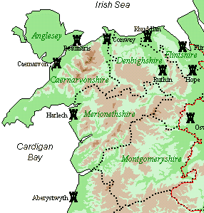
Poly-Symbols styleHere's a map (right) that demonstrates the use of bitmap symbols to represent locations. It shows the locations of the castles built by the English king Edward I (1272-1307) in North Wales. It was started by selecting "File | New", then adding each place manually by typing its name into the 'Add Record' dialogue (all of the places needed for this example are available from the placename gazetteer supplied with the program). The "Style Gallery" was used to select the Poly-Symbol style of map, then symbols set to plot as small bitmaps - the small "castle" is one of a library of symbols supplied with the program, though it's also possible to create your own. The relief-mapping option (hills & mountains) was invoked from the "Physical Geography" dialogue, and county boundaries set to plot as large dots. Area labels were added (green, italic) and symbol labels (black, Times Roman font), the symbol labels being moved manually such that they don't clash with one other. Finally, some text annotations were added ('Cardigan Bay' etc). | |
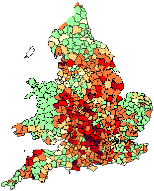
Area-Fill styleThe second example (left) is an Area-Fill map, showing the historical distribution of the surname Butler as a density map by Registration District. First, data relating to individuals bearing this surname was exported from the 1881 Census on CD-Rom and converted to database format, using the utility LDS Companion (not supplied). The resulting database file was then imported directly into GenMap, initially producing a point (dot-distribution) map. The the mapping style was changed by selecting "1881 Registration Districts" from the programs Style Gallery. One of the supplied colour schemes was chosen, to indicate the areas of greater concentration with darker colours. Finally, to get this graphic the image was exported from the program directly to the Windows clipboard, and saved in Adobe Photoshop as a GIF file. 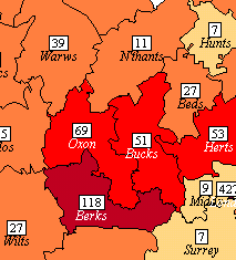
Now here's the same data again (right), this time plotted on a per-county basis. This was done by zooming in, then county names were added, and a figure (boxed) representing the number of Butler individuals per 100,000 of the 1881 population in each county. Note that this image file is only 4.6K in size, which makes it ideal for web pages as it shouldn't take much time to download. The other images on this page are similarly quite small files, the largest being only 15.7K. | |
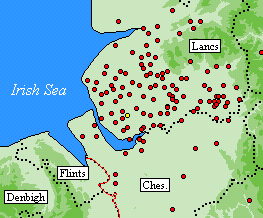
Simple Point styleNow here's a simple point (dot-distrbution) map, this time for the surname Prescot. The data for this was exported from the IGI, converted to database format by LDS Companion, and imported straight into GenMap. The spots could have been sized to indicate the relative numbers of events at each location, but for this example have all been left at their default size. This distribution shows that the surname was heavily concentrated in Lancashire during the 16th-19th centuries, and strongly suggests a derivation from the place name Prescot (indicated by the yellow spot in the centre of the image). | |
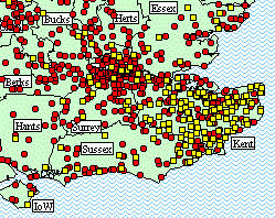
Poly-Symbols StyleFinally, what about showing two or more classes of data on the same map? This example shows the historical distribution of two major variants of one surname, Austin and Austen, showing that the latter variant is clustered in Kent; (a countrywide map illustrates the effect even more clearly). The author Jane Austen's family came from the Weald of Kent. The map was produced from the IGI again, assigning a red circle to Austin occurrences and a yellow square to all the Austens. The plotting of all other variants in the original file has been suppressed. County labels have been moved manually so they don't clash with the symbols. | |
Finally, view some more examples on the Gallery Page (these are finished and ready to print). 23 January 2003 |